GIS vs Survey - What to know about data differences
GIS and traditional survey data are both powerful tools for capturing and analyzing spatial information, but they serve different purposes and operate at different levels of precision. Survey data, collected with instruments like total stations, GPS, and LiDAR, provides highly accurate, site-specific measurements that are essential for engineering, construction, and boundary determination. GIS, on the other hand, integrates broader spatial datasets—such as aerial imagery, topographic maps, and demographic information—into layered systems that support analysis, planning, and decision-making at larger scales. While survey data offers precision, GIS offers context, and together they create a more complete picture of the built and natural environment. Let’s dive in just a bit deeper.
What is GIS?
GIS (Geographic Information System) is a digital system for capturing, storing, analyzing, and visualizing spatial (location-based) data. Think of it as a smart map that layers multiple types of data together—like parcels, utilities, roads, zoning, topography, aerial imagery, flood zones, demographics, etc.—to help with analysis and decision-making.
GIS data usually comes from sources like:
- Satellite imagery
- Aerial photography
- Public records (property boundaries, utilities, zoning)
- Existing surveys (fed into GIS)
It’s excellent for big-picture planning, mapping, and visualization.
Why Not Use GIS Instead of Survey Data?
Because GIS and surveying serve different purposes—one is approximate, the other is exact. I always tell a joke when I’m at the surveyors conferences. What does GIS stand for?? GET IT SURVEYED!! And here’s why.
- Accuracy & Precision
- Survey data: Collected in the field with total stations, GPS, or LiDAR, often accurate within millimeters to centimeters.
- GIS data: Usually generalized, sometimes off by several feet or more, depending on the dataset. It’s not suitable for construction staking, boundary determination, or engineering design.
- Legal Reliability
- Surveys are recognized in law for property boundaries, easements, and construction.
- GIS data is not legally binding—it’s for planning, not property definition. If a boundary is contested, courts require a licensed land survey, not a GIS map.
- Purpose
- Surveying establishes the exact ground truth for design and construction.
- GIS helps visualize relationships between data layers (zoning + floodplain + parcels + traffic, etc.), but it isn’t exact enough to set where a building corner should go.
- Scale of Use
- Surveying is micro-level (a single lot, road, or project site).
- GIS is macro-level (a whole city, watershed, or region).
One of the biggest things to not is that this data is complementary, not interchangeable. And if you’re using one without the other, you’re losing a lot of rich data that could be very helpful throughout a project.
- GIS gives planners, engineers, and cities a way to see the big picture.
- Survey data ensures that when it’s time to build, the lines and elevations are precise and legally defensible.
Here’s a further breakdown of some of the main differences in GIS and survey data.
|
Category |
GIS (Geographic Information System) |
Survey Data |
|
Purpose |
Big-picture mapping & analysis |
Precise measurement for design & construction |
|
Accuracy |
General (often ± several feet) |
High precision (millimeters to centimeters) |
|
Data Sources |
Aerial imagery, satellites, public records, existing surveys |
Field measurements with GPS, total stations, LiDAR |
|
Scale |
Macro (cities, regions, networks) |
Micro (specific site, parcel, or project) |
|
Legal Standing |
Not legally binding |
Legally recognized (property boundaries, easements) |
|
Use Cases |
Planning, zoning, asset management, environmental studies, visualization |
Construction staking, boundary surveys, topographic mapping, as-builts |
|
Cost & Time |
Lower cost, faster, but less precise |
Higher cost, slower, but exact and defensible |
|
Strengths |
Combines many datasets for analysis, good for decision-making |
Provides exact ground truth for engineering and legal use |
|
Limitations |
Not reliable for exact locations, can be outdated |
Limited to surveyed area, requires skilled professionals |
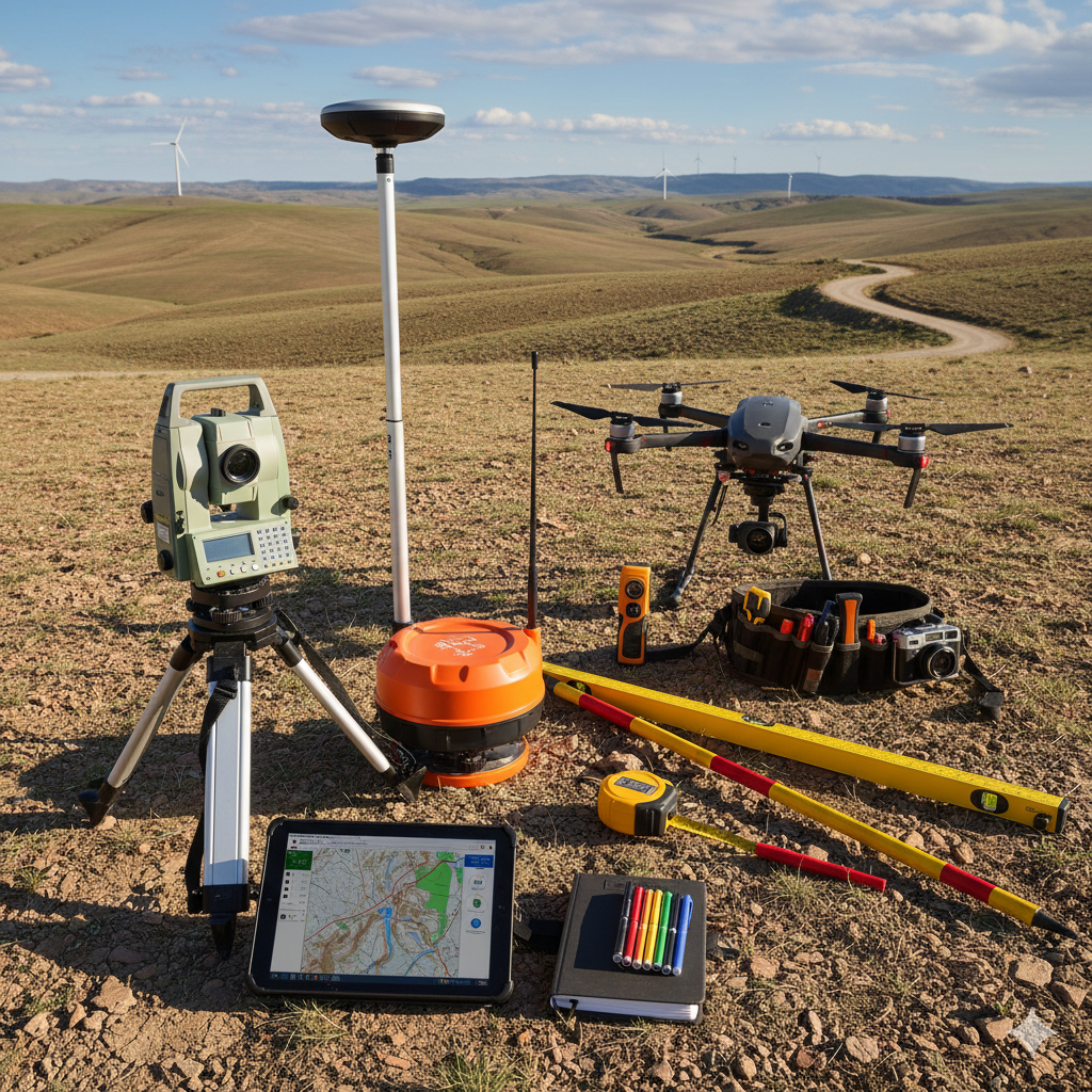
Not only are there differences in what is collected and mapped, but how it is collected and mapped. Here’s a breakdown of some key differences in the equipment used.
Equipment for GIS vs Survey Data Collection
|
Category |
GIS Data Collection |
Survey Data Collection |
|
GPS Receivers |
Handheld GPS units (Garmin, Trimble Geo, Collector apps) with accuracy of 1–3 meters. Often built into phones/tablets with ~5–10 m accuracy. |
Survey-grade GNSS receivers (Trimble, Leica, Topcon) with RTK (Real-Time Kinematic) correction, achieving cm-level accuracy. |
|
Field Devices |
Tablets, smartphones, or rugged handhelds running GIS apps (ArcGIS Collector, QField, Survey123). |
Data collectors linked to GNSS/Total Stations, rugged tablets, robotic total station controllers. |
|
Optical Instruments |
Rarely used; GIS relies more on imagery and GPS. |
Total stations, robotic total stations, theodolites for line-of-sight precision measurement. |
|
Remote Sensing |
Aerial drones with basic GPS, satellites, aerial imagery. |
Survey drones equipped with RTK/PPK GNSS, LiDAR payloads, photogrammetry cameras for high-accuracy mapping. |
|
Base Stations |
Not commonly needed (data usually tied to existing GIS coordinate systems). |
Used for GNSS corrections (RTK/PPK) to ensure survey-grade precision. |
|
Software in Field |
Mobile GIS apps (ArcGIS, QGIS Mobile, Collector). |
Surveying software (Trimble Access, Leica Captivate, Carlson SurvCE). |
|
Outputs |
GIS shapefiles, geodatabases, maps (approximate positions). |
Survey drawings, point clouds, legal plats, engineering base maps (exact positions). |
While GIS provides a powerful platform for visualizing, analyzing, and managing spatial data at a broader scale, survey data remains the foundation for precise, legally defensible measurements and design accuracy. GIS is best for planning, mapping, and decision-making across large areas, whereas surveying ensures the fine-level detail and reliability needed for engineering, construction, and property boundaries. Ultimately, the two are not competitors but complementary tools—survey data delivers the accuracy that GIS builds upon, creating a complete picture that supports both strategic insight and technical precision.