Mapcheck Analysis | Autodesk Civil 3D 2021 - Survey Tools

Our Consulting and Services Manager, Shawn Herring, wrote an article for this month's issue of AUGI World. Below is a portion of the article:
Well, since this is the Salary Survey edition of the magazine, I thought it was fitting to review some “survey” tools! After all, most projects begin and end with survey, but I feel like it often gets overlooked in Civil 3D.
GIS Data is also key to most civil projects. What does GIS stand for? GET IT SURVEYED! Just kidding.
That joke goes over much better with the survey audience. But I love working with GIS data on all my projects as well. I typically do not begin a project without using some sort of GIS data in addition to the survey data.
So here is some survey related tools I use on almost every project.
Mapcheck Analysis
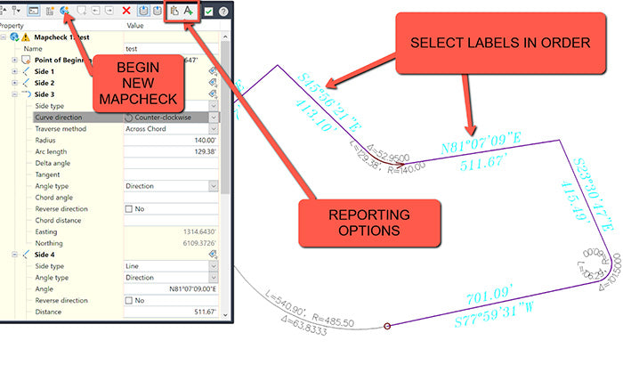
You can use the Mapcheck Analysis command to perform a mapcheck that is based on the precision of your label. This can be a line/curve label or parcels labels. It will read the direction of your bearing call (NW v/s SE, etc) so ensure that they are labeled correctly.
Type in MAPCHECK to launch the analysis, or find it from the Ribbon on the Analyze tab, to the far left under Survey.
To perform a mapcheck you must specify a point of beginning (POB) for each parcel. For each segment within the parcel, you select a label containing a direction, direction and distance, distance label, or curve label until the requirements to compute the next vertex of the current segment are met.
As you perform a mapcheck, selecting label by label, temporary graphics are displayed in the drawing to indicate the sides that have been entered for each parcel. The current side is displayed in bold indicating origin and direction for that side. The temporary graphics also provide a visual confirmation of possible errors, or indicate that the direction of a line or curve needs to be flipped or reversed.

Want to learn more about Civil 3D Survey Tools? Click here.
